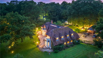
£2,000,000
Detached, 6 bed
Longparish Road, SP11 7AW
£2,000,000
Detached, 6 bed
Longparish Road, SP11 7AW

Compare 6 local agents, data from 14 active listings


We track 6 estate agents actively marketing properties in Wherwell, Test Valley, and we've ranked them all based on live listing data, average asking prices, and market share. selling a period cottage on Winchester Road or a family home near the River Test, finding the right agent is crucial for achieving the best price in this sought-after Hampshire village. Our team has analysed current listings, recent sales, and agent performance to bring you the most comprehensive comparison available.
Wherwell boasts a distinctive character with its historic timber-framed thatched cottages, proximity to the famous trout fishing waters of the River Test, and a peaceful rural setting that appeals to buyers seeking country living. Our inspectors and data analysts have found properties here command an average asking price of £621,782, with the market dominated by three and four-bedroom homes. Compare agents below to find the one that best matches your property and selling goals.

6
Active Estate Agents
£621,782
Average Asking Price
14
Properties For Sale
The Wherwell housing market reflects the village's unique position as one of Test Valley's most picturesque settlements. According to Rightmove and Zoopla data, the overall average house price in Wherwell over the last year stands at approximately £740,625, though this figure masks significant variation across property types. Detached properties average around £1,325,000, while semi-detached homes fetch approximately £693,750, and terraced properties typically sell for around £250,000. The market has experienced notable adjustment, with prices down 35% on the previous year and 25% below the 2021 peak of £981,667.
Our live listing data reveals that semi-detached properties dominate current inventory, with 8 homes available at an average asking price of £578,119. Detached properties, though fewer in number at just 3 listings, command significantly higher prices averaging £998,333. The overwhelming majority of properties for sale fall within the £500,000 to £750,000 price bracket, accounting for 9 of the 14 current listings. This concentration suggests strong demand from families and professionals seeking quality homes in this rural Hampshire village.
Transaction volumes in Wherwell remain steady, with Rightmove recording approximately 78 property sales within the last year across the SP11 postcode area. The village's appeal continues to attract buyers, particularly those drawn to its conservation area status, historic architecture, and proximity to both Winchester and Andover for commuting. The Test Valley's reputation for excellent schools, beautiful countryside, and high quality of life supports continued interest in Wherwell properties despite broader market fluctuations. Our experience shows that properties with authentic period features and well-maintained gardens tend to attract the strongest interest from the buyer demographic this village attracts.
Based on 6 live listings with an average asking price of £1,069,167.
Source: home.co.uk
See which agents are selling fastest and at the best prices in Wherwell.
Compare Estate Agents FreeThe Wherwell property market presents a clear picture of what attracts buyers to this Test Valley village. Our data shows that three-bedroom homes are the most prevalent in current listings, with 6 properties available averaging £488,325. Four-bedroom properties follow with 4 listings at an average price of £642,500, reflecting strong demand from families needing additional space. The premium end of the market includes a six-bedroom property currently listed at £1,950,000, showcasing the village's ability to attract buyers seeking substantial country residences.
New build activity specifically within Wherwell village itself remains limited, with no active developments verified in the SP11 7xx postcode area. The surrounding SP11 postcode includes villages such as Picket Piece and Whitchurch where new developments by Regal Estates and Foreman Homes are underway, but these are distinct settlements. A modest proposal for eight new homes on agricultural land between Beech Grove and New Barn Lane has been submitted to the emerging local plan, though this remains unverified as active. Buyers seeking new construction in the immediate area may need to consider surrounding villages or accept the character of the village's existing period stock.
Property types in Wherwell reflect its historic character, with the village known for picturesque timber-framed thatched cottages dating from the 16th century alongside more modern family homes. The predominant construction materials include brick, stone, cob, and thatch, with many properties featuring traditional timber windows and doors. This mix of period and contemporary housing creates a diverse market where agents must understand both the value drivers for historic properties and the appeal of modern family homes in this conservation area. Our team has found that agents who can speak knowledgeably about listed building regulations and the unique characteristics of chalkstream valley properties tend to achieve the best results for sellers in Wherwell.
Wherwell nestles in the valley of the River Test, one of England's most famous chalkstream rivers renowned for its trout fishing. The village developed originally on a gravel shelf above the valley bottom before extending up the valley sides, creating the characteristic landscape of willow and alder along the watercourses giving way to beech, ash, yew, and oak on the drier slopes. The River Test flows through the village parallel to the High Street, with more than one channel and a wide floodplain nearby, creating the water meadows that contribute to Wherwell's timeless rural charm. The proximity to this famous fishing river attracts buyers interested in countryside pursuits, particularly those with connections to the angling community.
The village's conservation area, designated in 1969 and comprehensively reviewed in 2004, covers most of the village and Priory parkland, excluding post-war development areas. This protection preserves Wherwell's architectural heritage, which includes the Grade II* listed Church of St Peter and Holy Cross and Wherwell Priory, also Grade II*, along with numerous Grade II listed cottages, barns, and the historic Watermill. The predominance of pre-1919 housing stock, including many 16th-century thatched cottages, means the village retains exceptional character that appeals to buyers seeking authentic English country living. Properties within the conservation area may face additional restrictions on alterations and extensions, which knowledgeable agents should be able to explain to prospective sellers.
Flood risk is a genuine consideration for property owners in Wherwell, situated as it is on the River Test's floodplain. The Environment Agency monitors river levels at Wherwell, with a flood alert issued when levels reach 0.65m (low-lying land flooding possible) and property flooding possible above 1.00m. The highest recorded level was 0.62m in March 2008, demonstrating the valley's susceptibility to rapid water level rises during heavy rainfall. Potential buyers should factor this into their property decisions and ensure appropriate insurance coverage. Our experience indicates that flood risk awareness is particularly important for properties along the river corridor and in low-lying areas near the water meadows.
The local geology presents additional considerations for property owners. The combination of alluvial floodplain and chalk downland creates the distinctive landscape, while the presence of clay soils in the broader region suggests potential for shrink-swell subsidence, particularly for older properties with shallow foundations. Properties with large trees nearby may be particularly susceptible to foundation movement as tree roots take up moisture from clay soils. These geological factors underscore the importance of thorough surveys when purchasing in Wherwell, especially for period properties. Our recommended approach includes obtaining a RICS Level 2 Survey for properties under £500,000 and a more comprehensive RICS Level 3 Survey for older or more complex properties, particularly those with significant trees in the grounds.
Sellers in Wherwell can choose between traditional high-street estate agents and modern online alternatives, each offering distinct advantages for different property types and seller circumstances. Evans & Partridge, based in nearby Stockbridge, currently leads the market with 3 active listings and a 21.4% market share, focusing on premium properties with an average asking price of £995,000. Their specialization in higher-value country homes makes them well-suited for Wherwell's period cottages and substantial detached properties. We have observed that their local presence in Stockbridge gives them particular insight into the Test Valley's premium village market.
Knight Frank and Savills, both operating from Winchester, each hold 7.1% market share with single listings at £695,000 and £545,000 respectively. These international-style agencies offer extensive marketing networks and sophisticated presentation services that can attract buyers from across the UK and internationally. For distinctive Wherwell properties, particularly those with listed building status or unique historical features, such premium marketing exposure can prove invaluable in reaching the right buyers. Our analysis shows these agents excel at positioning period properties to appeal to buyers seeking the English country lifestyle.
Goadsby, another Winchester-based agent with an average asking price of £500,000 across their single Wherwell listing, represents the traditional high-street model with local presence and market knowledge. Meanwhile, Austin Hawk and Graham & Co, both based in Andover, offer local expertise with an average asking price of £575,000. Online agents typically charge fixed fees between £999 and £1,999, making them attractive for properties at lower price points, though the limited local presence may disadvantage properties requiring specialist knowledge of Wherwell's unique market dynamics. Our team recommends considering the specific requirements of your property when choosing between these options, as the right agent depends heavily on your property type and target buyer demographic.

Start by comparing agents who actively market properties in Wherwell. Look at their current listings, average asking prices, and market share to understand their specialism and success rate in the village. Our data shows the market is dominated by Evans & Partridge for premium properties, while other agents focus on different price points.
Request free valuations from at least three agents. An experienced Wherwell agent will understand the local market nuances, including conservation area restrictions and flood risk factors that affect property values. We recommend asking specifically about how these local factors might impact your particular property.
Discuss how each agent plans to market your property. Premium agents like Knight Frank or Savills may offer professional photography, video tours, and international exposure, while local specialists like Evans & Partridge may have stronger connections with buyers seeking village properties. Ask to see examples of marketing for similar properties.
Estate agent fees in England typically range from 1-3% plus VAT (1.2-3.6% total). Consider whether you want sole agency or multi-agency representation, as multi-agency agreements usually cost 0.5-1% more but provide broader market coverage. Our experience suggests fee negotiation is often possible, particularly for straightforward properties.
Typical sole agency agreements run for 8-16 weeks. Ensure you understand the terms, including notice periods and what happens if your property doesn't sell within the initial period. We recommend clarifying whether the contract can be terminated early if you are dissatisfied with the service.
Ask for evidence of recent sales in Wherwell or similar Test Valley villages. Understanding how quickly properties sell and achieved prices compared to asking prices will help set realistic expectations. Our data provides a useful benchmark, but agent-specific performance data can provide valuable additional insight.
Don't automatically choose the agent offering the highest valuation. Our data shows that properties which sit on the market because they're priced too optimistically often end up selling for less than properly priced competitors. Request three valuations and compare them against our market data before deciding.
Understanding how bedroom count affects property values helps sellers position their homes correctly in the Wherwell market. Four-bedroom properties represent strong value in Wherwell, with 4 listings averaging £642,500, or approximately £160,625 per bedroom. This compares favourably with three-bedroom homes at 6 listings averaging £488,325, which works out to roughly £162,775 per bedroom. The slightly higher per-bedroom cost for three-bedroom properties suggests premium pricing pressure at this popular family size.
Two-bedroom properties show interesting dynamics, with limited supply (just 1 listing) at £545,000 reflecting strong demand from first-time buyers and downsizers competing for limited inventory. The single one-bedroom property listed at £210,000 represents a rare opportunity in the village for entry-level buyers. At the premium end, the sole five-bedroom listing at £500,000 and the unique six-bedroom property at £1,950,000 demonstrate the diversity of Wherwell's market, from family homes to substantial country estates.
Our analysis indicates that three-bedroom semi-detached properties in the £450,000-£550,000 range are particularly competitive, with multiple buyers often competing for limited stock. Properties priced realistically within this bracket tend to attract viewings within the first two weeks of marketing. Meanwhile, premium detached properties over £900,000 may require longer marketing periods but can achieve strong prices when presented to the right buyers, particularly those attracted to Wherwell's village character and River Test location.

Achieving the best price for your Wherwell property requires strategic pricing from the outset. Our market data shows that 9 of the 14 current listings fall within the £500,000 to £750,000 bracket, indicating strong buyer demand at this level. Properties priced competitively within this range tend to attract multiple viewings and can generate competitive offers, while those priced above the market norm risk stagnation and eventual price reductions that often result in lower final sale prices. Our team has observed that the most successful sales in Wherwell occur when properties are priced slightly below market average, generating competitive bidding that pushes the final price above the asking figure.
Negotiating agent fees is often overlooked but can significantly impact your net proceeds. While the national average estate agent fee is around 1.5% plus VAT (1.8% total), fees in Wherwell may vary based on the agent's reputation, marketing reach, and the specific services provided. Premium agents like Knight Frank or Savills typically charge higher fees but offer extensive marketing networks valuable for distinctive properties. Local specialists like Evans & Partridge may offer more personalized service better suited to Wherwell's unique market. Always request a detailed breakdown of what's included in the fee, from photography and floorplans to advertising and viewing arrangements. Our experience suggests that the cheapest fee is rarely the best value when selling distinctive village properties.
The valuation process deserves careful attention given Wherwell's market characteristics. With properties ranging from £210,000 for a one-bedroom home to £1,950,000 for a substantial estate, accurate valuation requires agent expertise in the village's specific market dynamics. Agents with proven track records in Test Valley, understanding of conservation area restrictions, and knowledge of the local buyer profile are best positioned to provide realistic valuations that attract serious buyers while maximizing sale proceeds. We recommend asking agents specifically about their experience with listed buildings and properties in flood-risk areas, as these factors significantly influence both valuation and marketing strategy.

6 properties currently listed across Wherwell. Here are the most recently added.
£2,000,000
Detached, 6 bed
Longparish Road, SP11 7AW
£2,000,000
Detached, 6 bed
Longparish Road, SP11 7AW
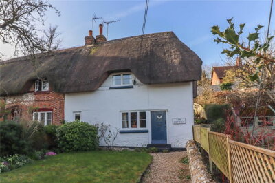
£650,000
Semi-Detached, 3 bed
High Street, SP11 7JG
£650,000
Semi-Detached, 3 bed
High Street, SP11 7JG
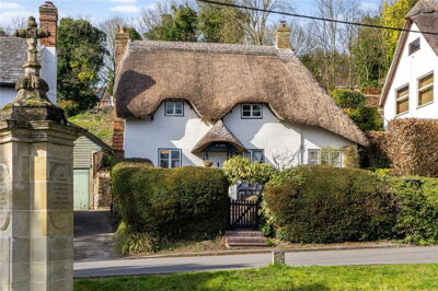
£545,000
Detached, 2 bed
High Street, SP11 7JG
£545,000
Detached, 2 bed
High Street, SP11 7JG
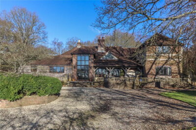
£1,950,000
Detached, 6 bed
Longparish Road, SP11 7AW
£1,950,000
Detached, 6 bed
Longparish Road, SP11 7AW
£695,000
Semi-Detached, 4 bed
Winchester Road, SP11 7JH
£695,000
Semi-Detached, 4 bed
Winchester Road, SP11 7JH

£575,000
Semi-Detached, 4 bed
Beech Grove, SP11 7JE
£575,000
Semi-Detached, 4 bed
Beech Grove, SP11 7JE
Get free, no-obligation valuations from the top-performing local agents. Compare fees, services, and track records before you decide.
Compare Agents FreeBased on current market data, Evans & Partridge leads with 21.4% market share and 3 active listings at an average price of £995,000, making them well-suited for premium Wherwell properties. Knight Frank, Savills, Goadsby, Austin Hawk, and Graham & Co each hold 7.1% market share with varying price specialisms. The best agent depends on your property type and price point, with premium agents better for higher-value homes and local specialists offering strong village market knowledge. Our analysis shows Evans & Partridge's strength in the premium sector, while other agents compete effectively in different price brackets.
Estate agent fees in England typically range from 1-3% plus VAT (1.2-3.6% total), with the national average around 1.5% plus VAT. In Wherwell's market, fees may vary based on agent reputation, services offered, and whether you choose sole agency or multi-agency representation. Always compare what's included in the fee, from marketing materials to viewing arrangements, and consider negotiating, particularly if your property is likely to sell quickly. Our data suggests that fee negotiation is common in this market segment, especially for properties in the mid-price range where competition among agents is strongest.
House prices in Wherwell over the last year were 35% down on the previous year and 25% down on the 2021 peak of £981,667, according to Rightmove and Zoopla data. The overall average house price is now approximately £740,625. This adjustment reflects broader market conditions, though Wherwell's desirable village character and limited supply may support values over time as the market stabilizes. Our team has noted that while prices have adjusted, the village continues to attract buyers seeking the unique lifestyle offered by this Test Valley location, with its conservation area status, River Test fishing, and proximity to Winchester.
Wherwell is a picturesque Test Valley village known for its historic timber-framed thatched cottages, proximity to the River Test (famous for trout fishing), and peaceful rural setting. The village has a primary school, a public house undergoing refurbishment (the White Lion, reopening in 2026), and is within reach of Winchester and Andover for services and commuting. The conservation area preserves much of the village's historic character, while flood risk from the River Test is a genuine consideration for residents. Our experience shows that buyers are typically drawn to the village's sense of community, its architectural heritage, and the outdoor pursuits available along the Test Valley.
Three and four-bedroom properties dominate the Wherwell market, with six 3-bed listings averaging £488,325 and four 4-bed listings averaging £642,500. Semi-detached properties are most common in current inventory (8 listings), but detached homes command the highest prices averaging £998,333. The village's period properties, including listed thatched cottages, appeal to buyers seeking authentic character homes. Our analysis indicates that properties with original features, well-maintained gardens, and off-street parking tend to attract the strongest interest, particularly those within walking distance of the village centre and the River Test.
No active new-build developments specifically within Wherwell village (SP11 7xx) could be verified. New developments in the broader SP11 postcode area include projects in nearby Picket Piece and Whitchurch, but these are separate villages. A proposal for eight homes on land between Beech Grove and New Barn Lane has been submitted to the local plan but remains unverified as active. Buyers seeking new construction in the immediate area may need to consider surrounding villages or accept the character of Wherwell's existing period properties, which form the overwhelming majority of the village's housing stock.
Look for agents with proven Wherwell or Test Valley market experience, understanding of the village's conservation area restrictions, and knowledge of local buyer profiles. Consider whether you need premium marketing (for distinctive period properties) or local specialist knowledge. Ask for evidence of recent sales in comparable villages, and ensure the agent can explain how factors like flood risk and listed building status affect your property's marketability. Our team recommends choosing an agent who can demonstrate specific knowledge of Wherwell's unique characteristics, including its position on the River Test floodplain and the implications of conservation area status for potential buyers.
Sale times in Wherwell depend on pricing, property type, and market conditions. Properties priced correctly for the current market typically attract interest within weeks, while overpriced properties can sit for months. The Test Valley market has seen adjustment recently, with prices down on previous peaks, making realistic pricing essential. Your agent should provide regular updates and advise on adjustments if needed. Our data shows that well-priced properties in the £500,000-£750,000 range tend to achieve sales within 8-12 weeks, while premium properties may require longer marketing periods to find the right buyer.
From £450
Essential for properties under £500,000 or conventional construction. Identifies key defects common in Wherwell's older properties.
From £650
Recommended for period properties, listed buildings, or homes over £500,000. Provides detailed structural assessment.
From £80
Required by law before marketing. Our assessors understand historic property energy efficiency.
From £300
For properties previously purchased with Help to Buy and now being resold.
Estate Agents In London

Estate Agents In Plymouth

Estate Agents In Liverpool

Estate Agents In Glasgow

Estate Agents In Sheffield

Estate Agents In Edinburgh

Estate Agents In Coventry

Estate Agents In Bradford

Estate Agents In Manchester

Estate Agents In Birmingham

Estate Agents In Bristol

Estate Agents In Oxford

Estate Agents In Leicester

Estate Agents In Newcastle

Estate Agents In Leeds

Estate Agents In Southampton

Estate Agents In Cardiff

Estate Agents In Nottingham

Estate Agents In Norwich

Estate Agents In Brighton

Estate Agents In Derby

Estate Agents In Portsmouth

Estate Agents In Northampton

Estate Agents In Milton Keynes

Estate Agents In Bournemouth

Estate Agents In Bolton

Estate Agents In Swansea

Estate Agents In Swindon

Estate Agents In Peterborough

Estate Agents In Wolverhampton

Compare 6 local agents, data from 14 active listings
Find AgentsHomemove is a trading name of HM Haus Group Ltd (Company No. 13873779, registered in England & Wales). Homemove Mortgages Ltd (Company No. 15947693) is an Appointed Representative of TMG Direct Limited, trading as TMG Mortgage Network, which is authorised and regulated by the Financial Conduct Authority (FRN 786245). Homemove Mortgages Ltd is entered on the FCA Register as an Appointed Representative (FRN 1022429). You can check registrations at NewRegister or by calling 0800 111 6768.
We use cookies to show you personalised content and improve your experience of our website. Find out more in our Privacy policy and Cookie policy.